“We feel the DNR led the Court down a deceptive road with their theory on why they claim this watercourse was natural and always there. Again our claim was this was man made by our ancestors and therefore disqualified it from being on the PWI. The Court doesn’t’ mention many of the documents we provided disputing the DNR’s claims. “
For background please see
Minnesota ‘Buffers Act’ will take thousands of productive acres from rural landowners
In MN, buffer debate for farmers ranges from U.S. Constitution to timing
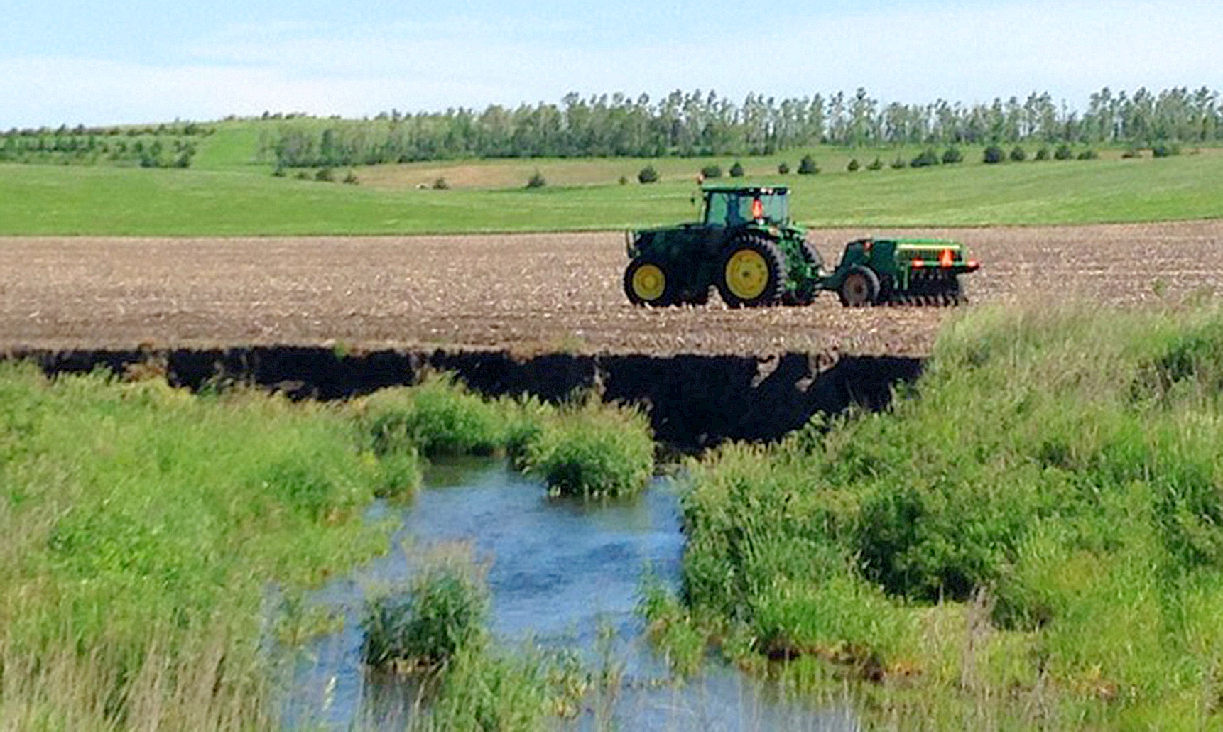
Gary Haugen is one of many landowners caught up in a years-long struggle with the Minnesota State Department of Natural Resources, and its confiscatory policy which creates ‘buffers’ along waterways in rural parts of the state, effectively taking thousands of productive acres from those with property impacted by the waterways. Haugen and several of his associates recently lost a court battle for their private property rights, and below is his explanation of the complex case, and response to the unfortunate decision. – FRR Editor
Commentary by Gary Haugen
A few days ago we received an opinion from the Minnesota Court of Appeals concerning our challenge of a determination of the Minnesota Department of Natural Resources (DNR) whether an unnamed public watercourse in Big Stone County, section 13 of Almond Township, was properly included in the state’s Public Waters Inventory (PWI). Before filing an appeal of the decision we had the local government agencies review our request. These agencies agreed with us and in January 2016, the Big Stone County Board of Commissioners, the Big Stone County Soil and Water Conservation District Board of Supervisors, and the Upper Minnesota Watershed District Board of Managers petitioned the DNR to remove the Watercourse from the PWI on the ground that the DNR incorrectly designated the Watercourse as a public water. The DNR denied the request in May 2016, determining that “substantial evidence” supported the Watercourse’s designation as a natural watercourse. The DNR concluded that the Watercourse was “properly included in the public water inventory” and denied the petition to remove the Watercourse from the PWI. In August 2016, the Big Stone County Board of Commissioners and the Big Stone County Soil and Water Conservation District Board of Supervisors again requested that the DNR remove the Watercourse from the PWI. In November 2016, the DNR notified the county that it would not reopen its May 2016 determination.
We were disappointed with the Court’s support of the DNR’s decision for a number of reasons which we will try to address here.
The Court spends a fair amount of time addressing the process in 1979 for determining what went on the Public Waters Inventory (PWI). On page 8 they state, “The DNR published a revised PWI list and map in an official newspaper for Big Stone County in September 1980, directing that any landowner challenging a designation should submit such challenge to the DNR within 90 days. The statutory time period expired in December 1980. It is uncontested that the designation of the Watercourse as a public water was not challenged by relator or anyone else within this statutory time period. Based on the plain and ambiguous language creating a 90-day statutory time period, the DNR therefore determined that relator’s petition is time- barred. We agree.”
We argued the following in our brief. In a letter dated June 12, 1980, Item DNR0000076 from Larry Seymour, Director of the Division of Waters of the MN DNR, to the Big Stone County Commissioners, the following statement was made by the DNR regarding landowners concerns over Public Water Designations. “Furthermore, the landowners have every right to till, crop, or pasture public waters or wetlands on private land. Designation as public waters or wetlands means only ONE thing, that a DNR permit is required before permanent changes in the course, current or cross section can be made.” This reassurance was conveyed to the landowners at that March 7, 1980 public meeting also. The letter sent to the Big Stone County Commissioners and statements made to the landowners at the public meeting clearly demonstrate that the agency did not disclose the intended use of the property and that there would be a taking of the land. It is obvious the intent of this statement by the DNR was to reassure landowners that very little would change with a PWI designation and to limit the number of objections from landowners.
With this reassurance, the landowners did not object to the above- named watercourse being put on the PWI. The Court states on page 12 “First, relator argues that the DNR failed to notify landowners that large amounts of land would be taken at a later date in the form of 50-foot buffer strips along the waterway, as a consequence of the PWI list. Relator argues that the DNR’s failure to provide notice of the consequences of the Watercourse being designated as a public water amounts to a due-process violation. Minnesota courts recognize that it is “both unrealistic and unnecessary under the law” to require the DNR to provide notice of “every possible outcome” of an agency decision. Here, the DNR did not violate relator’s due-process rights by failing to alert landowners in 1980 that, 35 years in the future, the PWI could inform the DNR’s designation of certain lands as buffer areas.” We understand that every consequence cannot be predicted but we feel that taking 12 acres of land per mile from a landowner without compensation is no small consequence especially given the fact as we point out above, the DNR specifically told the landowners in 1980 they had the right to till, crop, or pasture public waters.
The Court describes their process of what they look at in these cases on page 4 where they state “[D]ecisions of administrative agencies enjoy a presumption of correctness, and deference should be shown by courts to the agencies’ expertise and their special knowledge in the field[s] of their technical training, education, and experience.” Reserve Mining Co. v. Herbst, 256 N.W.2d 808, 824 (Minn. 1977). Our role as a reviewing court is to determine whether the agency has taken a “hard look” at the problems involved, and whether the agency “genuinely engaged in reasoned decision-making. We will not disturb an agency’s decision unless it reflects an error of law, the findings are arbitrary and capricious, or the findings are unsupported by substantial evidence. If an agency engages in reasoned decision-making, we will affirm the agency’s decision, even if we may have reached a different result.
Our only chance was to prove the agency acted arbitrarily and capriciously which the Court addresses on page 9 where the Court states “A reviewing court will uphold the DNR’s decision if its factual findings are supported by substantial evidence and the decision is not arbitrary or capricious. An agency’s decision is arbitrary and capricious if the agency (1) relied on factors the legislature never intended it to consider; (2) entirely failed to consider an important aspect of the problem; (3) offered an explanation for the decision that runs counter to the evidence; or (4) rendered a decision so implausible that it could not be ascribed to a difference in view or the result of agency expertise.”
In our brief we explained how many of the DNR’s statements were proven false and highly disputed by numerous other government agencies and our Consultant Widseth Smith & Nolting (WSN), an engineering firm the DNR has used for many of their projects. On page 10 the Court states “The DNR also reviewed plat maps, surveyor notes, and aerial photographs to verify the “accuracy and appropriateness” of the 1984 PWI determination. The DNR verified its interpretation of these materials with two experts, who confirmed the DNR’s findings. Based on its review, the DNR calculated that the drainage area of the Watercourse is 11.3 square miles—well in excess of the two-square-mile definition of a “public water.”
We provided evidence from the Bureau of Land Management in Washington that directly contradicted the statements the DNR used in their brief about the 1870 survey map and field notes. We had WSN calculate the drainage area of our ditch and the northern portion has less than 2 square miles of drainage. We also gave the court examples of other landowners who had drainage areas of less than 2 square miles which the DNR convinced the Court that these had nothing to do with our case and were successful at removing them from evidence presented. The 11.3 miles the DNR confused the Court with is the total drainage area of the entire watershed, not the area going into our ditch. A red herring. Mark Reineke, a geologist from Widseth Smith & Nolting described their whole antiquated process in an email the DNR did not include in the list of correspondence they were supposed to give to the Court.
“The DNR, in the early 1980’s, utilized the USGS 1:24,000 7.5 minute series topographic maps, along w/ a planimeter, to outline 2 square miles of drainage area to help define the beginning of a watercourse. In their brief, they stated: “Contributing versus non-contributing areas within the watershed were not applicable and therefore, not used in making PWI determinations”. This comment is wrong. When determining a stream, one of the qualifications is that there is 2 sqmi of upstream drainage area. If a basin DOES NOT CONTRIBUTE WATER (ie. Non-contributing), then it is CLEARLY APPLICABLE to setting how much lands actually CONTRIBUTE to the stream. If the lands don’t contribute…then they shouldn’t count. The fact is they didn’t have an easy and accurate way to produce these contributing vs non-contributing delineations in those days (like I said, the topo maps have either 5’ or 10’ contours in that area…so that is as accurate as you can get from them), but we do today…and WSN used that technology to produce our models. “
Our point that we tried to get across to the Court in all of this is that there are many mistakes in the PWI because the DNR did not have the technology we have today such as LIDAR, to determine watershed areas. I am a certified ditch viewer and I explained to the Court in my brief that I would never be able to defend the watershed area they have for this ditch if I was assigned to determine which areas should be assessed into the ditch. As an example the large wetland west of my house is included in the DNR’s watershed area of this ditch. In Widseth Smith & Nolting’s model they showed that it would take over a 40” rainfall event for water from that area to reach the ditch. It’s never happened. At least not since Noah.
On page 8 the Court states the following “Relator argues that the petition is not time-barred because the statute authorizes the DNR to revise the PWI to correct errors. The Minnesota legislature granted the DNR discretion to “revise the public waters inventory map of each county . . . as needed, to . . . correct errors in the original inventory.” Minn. Stat. § 103G.201(e)(2)(i) (2016). Relator argues that the DNR is acting arbitrarily and capriciously by denying his request to revise the PWI under section 103G.201(e). Relator’s argument ignores that the statute is permissively framed to provide that the commissioner “may revise” the PWI. Minn. Stat. § 103G.201(e)(2)(i) (emphasis added); see also Minn. Stat. § 645.44, subd. 15 (2016) (defining “may” as permissive rather than mandatory). A statute that uses the term “may” is “permissive and imports the exercise of discretion.” State ex rel. Klimek v. Sch. Dist. No. 70, Otter Tail Cty., 204 Minn. 279, 281, 283 N.W. 397, 398 (1939). While the legislature vested the DNR with the discretion to revise a PWI list to correct errors, it did not compel the DNR to do so, and section 103G.201(e) does not prevent application of the statutory time-bar here.
In talking with legislators about this word “may” used instead of the word “shall,” everyone of them has stated this should be changed and was most likely not the intent of the legislature. It is this simple word “may” that an attorney friend of mine from one of the best law firms in the state regarding water issues advised me they would be willing to take my case but it could possibly be the part of the law that could lose the case. He told me I could end up spending a lot of money with only a 25% chance of winning. That is why I chose to represent myself with limited time with attorneys only to make sure I followed procedures correctly and filed the correct paperwork. The word may in this case would be like having a problem with a new car expecting warranty to cover the problem only to find out that in the fine print the dealer points out that the warranty says the dealer may fix the problem instead of shall fix the problem.
The Court on page 11 makes the following statements. “We discern no error in the DNR’s determination that relator’s evidence was not compelling because it ran counter to historical factual evidence present in plat maps, surveyor notes, and aerial photographs.
In light of its review of historical documents from 1870, 1871, 1938, 1955, and 1971, the DNR determined that the Watercourse is a natural watercourse and is properly included on the PWI list and map as a public water. This determination is entitled to deference, particularly in light of the fact that this subject matter falls within the DNR’s area of expertise. See Reserve Mining Co. v. Herbst, 256 N.W.2d at 824. The DNR’s July 17, 2017 decision to uphold the 1984 PWI determination as it relates to the Watercourse is supported by substantial evidence in the record and is not arbitrary or capricious. See Saif Food Mkt., 664 N.W.2d at 430. We therefore affirm the DNR’s decision denying relator’s petition.”
We feel the DNR led the Court down a deceptive road with their theory on why they claim this watercourse was natural and always there. Again our claim was this was man made by our ancestors and therefore disqualified it from being on the PWI. The Court doesn’t’ mention many of the documents we provided disputing the DNR’s claims.
I hope you’ve stuck with me up to this point because here is where this story gets interesting. My wife and I have put a lot of prayer time into this case and this is where I believe God showed up and answered some prayers. On September 25, 2017, just a few days before I had to file our brief, a Big Stone County Highway Department employee was trying to trace down the smell of a dead mouse in the file room. They moved a filing cabinet and found a 1911 map behind it. The map was a proposal for the construction of County Ditch 9 just downstream from the land owned by my ancestors at that time. The construction would involve deepening a natural watercourse to drain a lake bottom just over the hill from my ancestor’s property. This natural watercourse in the next section southeast of the area that my ancestors owned is the natural watercourse the DNR is theorizing was always connected to the ditch passing through our land. If this theory was correct and these two areas were connected in 1911 the DNR would be right. If they were not connected in 1911 we would be right. We were able to find the corresponding viewer’s reports for the 1911 map at the Historical Society in St Paul. When a new public ditch system is proposed, viewers are sent out to determine which landowners benefit from the ditch and also how much they benefit.
The process used back then was very similar to how it is done today. None of the property in Section 13 along what is now labeled as a Public Waters Ditch was shown on the map or mentioned in the Viewer’s reports! These documents proved that the area in section 13 was not connected to the natural watercourse downstream until our ancestors excavated through two high areas and dug the ditch artificially sometime after 1911! If this proposed ditch would have been constructed in 1911, our ancestors would not have had to pay anything because there land would not have benefited from the ditch because there was no connection between the two areas at that time. What this meant is that all the theories the DNR presented to the Court were false and the models done by our consultant, Widseth Smith & Nolting were correct. We filed our case on August 10, 2017 so this was new evidence we needed to try to get into the Court. We sent this evidence to the DNR and Attorney General first to see if they would agree to drop the case and remove this from the PWI. They refused so we sent the documents to the Court and included it in our brief. The Attorney General then petitioned the Court to not allow this evidence since it was new.
The Court later agreed with the Attorney General that new evidence could not be added so we were not allowed to include the evidence that beyond a shadow of a doubt proved what we, the Soil and Water Conservation District, The Upper Minnesota Watershed, Big Stone County, and our consulting firm had been saying was absolutely true. The Attorney General and DNR realized the Court would see this evidence even though it would not be allowed because it was late, so they make the following statements about it on page 25 of their brief. “ Relator points to recently discovered evidence from 1911, submitted to DNR on September 28, 2017, that allegedly supports his position that the watercourse is a manmade watercourse. While DNR maintains that such documents are outside the Record as they were not before DNR when issuing the July 2017 Order, evidence that the watercourse was being considered to be part of a public ditch system does not mean it was not a public water nor does it overcome the substantial evidence supporting the DNR’s conclusion that the Watercourse was properly place on the PWI.” They go on to say-“The fact that a natural watercourse has been altered and is used as part of either a public or private ditch system has no bearing on whether or not the watercourse is a public water.”
The 1911 Map and Viewer’s reports showed that the land in Section 13 was NOT being considered to be part of the public ditch system. This statement by the DNR is absolutely false and I believe it was meant to confuse the Court and hopefully get them to overlook this. I believe this is another point that would fall into the “red herring” category.
If you have stuck with me through this whole explanation, what does this say for the credibility of the DNR? As the Court stated, they rely heavily on the expertise of the agency because they are the experts. Why could all the local government agencies see this was an artificial watercourse but the DNR couldn’t? What does this say about the Attorney General’s integrity? Is it all about winning no matter what? If there is a legal way to win the case you go that route even though you know it’s wrong?
In closing I will say I’m not sure where we go from here. We need to get the word out to our legislators to write good statutes and not pass laws and let government agencies then write the rules for the law. There are many mistakes in the PWI all over the state and the DNR does not want to correct them and they won’t have to if things stay as they are. When we were notified of the date, January 18, 2018, when the Appeals Court would be discussing our case, we were told that we could not come and present any oral arguments before the Court because we were not represented by an attorney! I was able to struggle through this without much attorney help because of my experience in water issues. I am a certified ditch viewer with the Minnesota Viewer’s Association, I have served on the Upper Minnesota Watershed Board for the past 10 years , and worked as Maintenance Supervisor for Big Stone County Highway Department for 34 years. If you hired an attorney you could easily spend a ton of money trying to fight a decision against you by a government agency. I now understand the time it would take an attorney to do this work for you. It shouldn’t be that way. When we gave the 1911 map to the Attorney General, they should have threw up the white flag and surrendered. Isn’t the Attorney General supposed to look out for the consumer?
Thank you to all those who helped with financial support to get this case before the Court.
Gary Haugen
Free Range Report
Thank you for reading our latest report, but before you go…
Our loyalty is to the truth and to YOU, our readers!
We respect your reading experience, and have refrained from putting up a paywall and obnoxious advertisements, which means that we get by on small donations from people like you. We’re not asking for much, but any amount that you can give goes a long way to securing a better future for the people who make America great.
[paypal_donation_button]
For as little as $1 you can support Free Range Report, and it takes only a moment.