When used with prudence, drones can be a potential tool to better control our agricultural productivity and to best invest our limited resources.
Why Drones Are the Latest Buzz in Agriculture

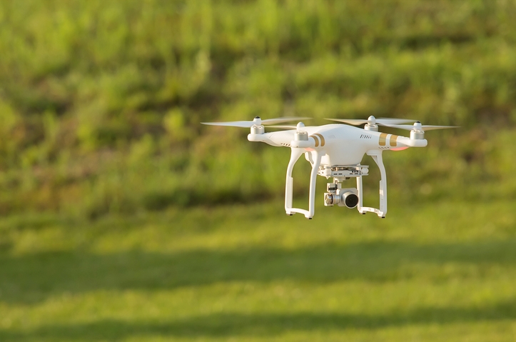
By virtue of their small size and easy operation, drones are cheaper and more efficient than manned aircrafts, manual scouting or satellite imaging. Credit: minhocos/Flickr, CC BY 2.0
Drones, or unmanned aerial vehicles (UAVs), have become synonymous with death and destruction. Then again, as UAVs have become more affordable and ubiquitous, they have also been adapted for diverse applications – ranging from the quixotic (hurricane-hunting, Amazon delivery) to the recreational (photography and videography) and the utilitarian (3D mapping, remote-sensing, policing and disaster management). In fact, if projections are anything to go by, these ‘harbingers of doom’ could become indispensable tools to promote life in the next decade or so.
As technology has infiltrated our lives through smartphones, computers and the internet, agriculture has remained the last bastion of tradition as an enterprise of human labour and intellect. Despite mechanisation, much of farming involves human labour and legwork. Farmers walk down their fields checking for plant health, the presence of weeds, bugs, parched soil and other overt signs of distress. However, even with a trained eye, it is often hard to notice diminished photosynthesis or signs of pathogen infestation early enough to avoid large losses. This, in turn, has led to aculture of prevention where farmers have resorted to the excessive use of water, fertilisers, pesticides, etc. Otherwise, the cost of non-intervention, or even late intervention, is massive crop failure.
As the world’s population inches toward eight billion, the focus worldwide has shifted to feeding it in a sustainable way. This has led to the emerging concept of precision agriculture – a farm management concept that is based on observing, measuring and responding to both inter- and intra-field variability in crops. The goal, simply stated, is to more efficiently apply a farm and farmer’s limited resources to gain maximum yield. This requires constant observation, realtime feedback and an objective analysis of the outcomes in terms of crop yields, plant health and other data. Drones are fast becoming an efficient tool to collect aerial images and to use them to generate such meaningful data.
By virtue of their small size and easy operation, drones are cheaper and more efficient than manned aircrafts, manual scouting or satellite imaging. They provide cheaper imaging, greater precision (drone cameras can take centimetre-level images) and earlier detection of problems due to more frequent index reporting and total-field scouting (as opposed to monitoring around the perimeter). These readouts can then be used to detect density issues like hotspots (in a crowded beet field) or to identify contour problems such as shading or drainage problems.
While the developments in drone technology are critical, the development of sensors and downstream analytical packages, to generate meaningful insights from these farmland images, is the real driver for the current use of drones in agriculture. Today, small startups – like the San-Diego-based Slantrange – and large agricultural behemoths like John Deere are using aerial-image-based data in the visible and near infrared parts of the spectrum to assess plant height, count and health, nutrient deficiency, weed or pathogen infestation, etc.
How does the technology work?
Drones in agriculture are simply a low-cost aerial camera platform, equipped with an autopilot using GPS and sensors for collecting relevant data, like a regular point-and-shoot camera for visible images. While a regular camera can provide some information about plant growth, coverage and other things, a multi-spectral sensor expands the utility of the technique and unleashes its full potential. It allows you to see things which you cannot see in the visible spectrum, such as moisture content in the soil, plant health, stress levels and fruits.
In the 1970s, a NASA scientist named Compton Tucker used reflected light from plants to quickly and easily identify vegetated areas and their overall conditions in satellite imagery using a method called normalised difference vegetation index (NDVI).
The basic principle of NDVI relies on leaves reflecting a lot of light in the near-infrared, in stark contrast to most non-plant objects. Leaves are green in colour due to the presence of a pigment called chlorophyll, which strongly absorbs almost all non-green light from the visible spectrum of sunlight and reflects mostly green light back to our eyes. Live green plants absorb solar radiation in the photosynthetically active region (PAR) and leaf cells re-emit the solar radiation in the near-infrared spectral region. Thus, a healthy plant appears dark in PAR and bright in near infrared.
On the other hand, in an unhealthy or stressed plant, the leaves reflect less near-infrared light even if its emissions in the visible spectrum remain unchanged. Tucker found that combining these two signals can help differentiate plants from non-plants and a healthy plant from a sickly plant. This work gave rise to indices like the NDVI, which is now used to assess plant health.
With the advancement of technology, it is now relatively inexpensive to modify a consumer camera to collect infrared bands and to fly it aboard a small drone. The ground resolution of UAV imagery is more than one thousand times higher as the reflected radiation does not have to travel through the entire atmosphere to be collected, and the incident light is dramatically more varied. As Salman Siddiqui, head of the International Water Management Institute’s GIS remote sensing and data unit, told The Guardian in December 2015,
Using near-infrared, you can identify stress in a plant 10 days before it becomes visible to the eye. When a plant goes into stress, it’s either due to a water or fertilizer shortage, or because it’s being attacked by a pest. Photosynthetic activity decreases and that affects the chlorophyll. That’s what the near-infrared sensor can detect, but our human eye can’t see it until it’s more advanced.
That 10-day warning could prevent large-scale crop losses. Siddiqui also added, “If a crop is being attacked by insects, the whole area can be affected, not just one farmer. With UAVs, if you can figure this out before it spreads, you can save the whole area.”
Good software is crucial
To survey crop fields with a drone, you start by planning the flight path of the drone that will best cover the plot. Many of the latest agricultural drones come with flight-planning software that let you outline a box around the field you want to survey on Google Maps. The flight plan is then automatically computed. The drone then flies over the field in a pattern while taking pictures with one or more cameras with special light sensors. These pictures are geo-tagged and overlap each other.
After landing, special software is used to stitch together the geotagged photos into a large mosaic and processed to interpret the amount of light that is reflected in different wavelengths. Processing this data makes areas of poor growth or stressed plants easy to identify. Generating this data immediately and quickly opens to doors to better interventions and decision-making. The last step in this process is reviewing and taking remedial action. Prescriptive software packages also come up with comprehensive recommendations based on the field survey but these are not completely reliable yet.
Processing images is the most challenging part of any drone-based agricultural operation. Here, downstream software packages use the high-resolution images and data from the different sensors on a drone to generate a meaningful and insightful image. Most agricultural drone operators use a tool like Pix4D or Correlator3D to turn these aerial images into useful data. Some others use proprietary software packages custom-built for their devices. The challenge however is that, being computation intensive, they rely on cloud services that are not always available in agricultural areas, especially in the context of emerging economies like India.
While some other general-purpose programs (like Pix4D) are available, they involve a steep learning curve. In developed economies of the west, companies also provide only a back-end processing service that will analyse the data once uploaded and generate reports for you. Other smaller start-ups have developed their own sensors, software packages and extensive back-end analytics support that can be used with any UAV.
Some of this software is also built to avoid reliance on cloud-computing; all analytics can be performed on a local computer once downloaded and set up. Some companies, like Slantrange, have also developed core intellectual property enabling the identification of weeds from crop plants using multi-parametric image analysis. This further extends the capabilities of drone-based agriculture systems.
Applications of the technology
According to the Association for Unmanned Vehicle Systems International (AUVSI), the use of drones in agriculture is expected to make up to 80% of their future commercial UAV market. While technology is still catching up to the use of drones as implementation tools, the field is indeed ready for their use in data collection and analysis for precision farming.
In day-to-day operations, routine surveillance by drones can help farmers catch problems faster and react more quickly, which can help prevent crop losses. It can also help farmers use chemicals, fertilisers and pesticides in a need-based manner to reduce costs and pollution of the waterways. In the long-term, the data generated by drones can help gain a more accurate and detailed picture of how crops are reacting to these management strategies, which can lead to more effective use of limited resources. Even for organic farmers, monitoring for disease and drought could be made easier and effective with aerial sensors.
As the number of drone-users grows, the impact on the farming sector could be huge. The American Farm Bureau Federation estimates farmers’ return-on-investment alone could be $12 per acre for corn and $2-3 per acre for soybeans and wheat. Many countries have now adopted the use of drones in agriculture. In fact, despite its notoriety and sophistication in military hardware and software, the US’ commercial drone market lags behind a substantial number of countries across South America, Asia and Europe. Canada, for example, has allowed drone use in agriculture for years. Japan alone has an estimated 10,000 unmanned aerial vehicles, including many helicopters in operation for agriculture.
Similar gains could be realised in emerging economies as well. However, the system will need to be tweaked due to smaller plot sizes and ownerships. In smallholder settings, NGOs and the public sector could start using drones, along with large landholders and farmers’ cooperatives. Further, drone-based-analytics could also provide useful insights to government for policy decisions as well. The use of such sequential data in predicting crop yields could help farmers plan their finances and for the government to announce relief packages or subsidies pre-emptively. This becomes especially critical in countries like India, where crop failures are frequent, unpredictable and difficult to handle due to sheer scale. By the time a government is aware of the problem and the relief machinery gets rolling, the problem is out of control and many lives are affected.
Evidence suggests that, when used with prudence, drones can be a potential tool to better control our agricultural productivity and to best invest our limited resources. Trials have been underway in Sri Lanka, Brazil, Uganda, Tanzania, Peru and many other emerging markets, where governments and private industry are examining the utility of these tools in their own local contexts. In September, the International Water Management Institute carried out trials in Sri Lankausing an eBee drone equipped with a near-infrared sensor. The trials showed how this can give farmers early warning of problems anywhere in their fields. In Uganda and Tanzania, the International Potato Centre has been carrying out drone trials in partnership with the national bureau of statistics in both countries, with the realisation that accurate data is crucial for effective agricultural policymaking.
Such unreliability of data in developing countries extends beyond crops and to livestock, too, where it can cause problems in the event of a disease outbreak. The use of near-infrared and visible spectra also allows this technology to observe wildlife and forest cover. While companies continue to develop software for tracking animals, livestock and poultry in large-scale ranch operations, it is an important application that the governments can also use to track illegal poaching, logging and to prevent deforestation in a more targeted way.
The UN’s Food and Agriculture Organisation (FAO) is researching how drones might be used in these situations, as part of training veterinarians in dealing with foot-and-mouth disease. As part of an FAO trial in Kenya, using a HuginnX1 drone, aerial surveillance was used to identify livestock distribution before inspection by the veterinary staff to assess the overall population and its health. Other proposed applications include assessing wildlife-related conflicts, encroachments and damages by wildlife to crops.
The onboard systems developed for drones will combine the Brazilian Agricultural Research Corporation’s expertise in agriculture with Qualcomm’s in wireless technologies to collect, process, analyse and transmit realtime crop intelligence to farmers and environmental stakeholders in Brazil. The crop intelligence data produced in realtime by drones flying over fields will be delivered to the farmer in an easy-to-read format via an LTE-connected smartphone or tablet.
Interrupting the buzz
Although the use of drones in agriculture holds tremendous potential, it is an infant field, especially in India. The adoption of drones and precision agriculture also requires the development of an ecosystem of financial, legal and social policies. From the establishment of government rules and policies over the use of its airspace to the development of laws that prohibit the use of drone surveillance over private property, this is a multifaceted issue whose boundaries are not yet fully defined.
There are also technical challenges to be overcome. While detecting plant health in general can be done relatively easily based on NDVI, identifying crop plants from weeds is more challenging. Slantrange, the San Diego based start-up, has currently tested its algorithm on more than 2,000 crop plants. While many of the commonly cultivated plants are amenable to such analyses, software optimisation is critical to the process.
There are other analytical and implementation challenges with respect to drone usage:
- Outdoor use is highly weather dependent
- Imaging can vary depending on sunlight and cloud cover although one can account for ambient lighting conditions
- Limited internet access and cellular infrastructure can make it harder to rely on cloud based computing services
- Higher costs especially for small landholders in emerging economies
- Limited flight times
- Maintenance costs and resources
- The need for skilled operators
- Uncertain government regulation that need to be overcome before this technology can be widely applied.
That said, the application of technologies like this requires the development of a whole ecosystem of government policies, public funding and private entrepreneurship that requires a concerted and collaborative effort. As author Jim Butcher rightly said, “One can have only as much preparation as he has foresight.” With the recent technological developments, this ‘eye in the sky’ technology might finally enable us to see a little ahead in time – at least when it comes to the health of our croplands.
Suvasini Ramaswamy

*Free Range Report*
thanks for information… yah, sometimes we get challanges to implement drone in real yield…